.png)


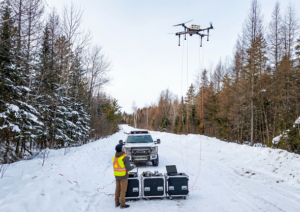
Airborne Surveying
High-resolution data acquisition using UAV surveys optimized for precision, enabling clearer targeting and stronger exploration decisions.
3D Modeling & Data Processing
Refining complex geophysical and geospatial data into decision-ready insight through high-resolution imaging of surface and subsurface features.
Geological Interpretation
Expert structural analysis and mapping that uncover structure, define targets, and guide drill strategy
Engineering R&D
Custom airborne engineering solutions designed to solve survey limitations, improving performance, reliability, and data consistency in complex exploration environments.
End-to-End Airborne Survey Solutions
Rosor manages every stage of your program. Survey design, UAV deployment, data processing, and geological interpretation are all handled in-house so your team receives results, not raw files.
Trusted by
50+ Clients Worldwide
Rosor Exploration Advantages
Purpose-built platforms, expert geological interpretation, and end-to-end quality control. This is what sets Rosor apart from standard survey providers.
At Rosor Exploration, we harness cutting-edge airborne survey technology and pair it with expert geological interpretation. Our approach acts as an extension of your geological team, delivering precise, actionable insights to accelerate exploration and resource discovery.
Industries We Serve
Our airborne geophysical solutions are designed to support diverse sectors.

Rosor has helped our exploration efforts both on the ground and with the drill bit utilizing their drone-borne surveys. They communicated effectively throughout the work program and processed the data within our tight time frame. We enjoy working with the team and look forward to using them again.
Nathan Tribble
VP Exploration
Throughout the duration of the project, Rosor maintained clear and efficient communication with our team. They demonstrated a strong commitment to meeting deadlines by processing the collected data within a very tight time-frame, ensuring that our exploration schedule remained on track. We found our collaboration with the Rosor team to be highly enjoyable and productive. Based on this positive experience, we are eager to continue working with them in the future.
Peter Colbert
Chief Financial Officer
Testimonials
What Our Clients Say


Smarter Gold Exploration - Leveraging UAV LiDAR, Magnetics, and Machine Learning for Target Generation
.png)
A Tale of Two Surveys - Leveraging UAV LiDAR, Magnetics, and Machine Learning for Target Generation
.png)
Harmonization in a Drone Survey - When a Survey is Perfectly Executed from Start to Finish
.png)
Flying High - When Production Reaches New Heights in
Low Conditions
Case Studies